Heavenly tombstones: Fun with Gold Country geology
Field Trip! Have you ever seen these distinctive rocks on the back roads of the Sierra foothills?
As you drive through the back roads of Gold Country on the west side of Hwy 49, you will see unique rocks that appear to be grave or tombstones. They are glittering and colorful vertical rocks, jutting right out of the ground in this cattle grazing country. Miles and miles of it!

Tombstones
When the sun is right, these rocks can make fabulous ‘models’ for a photographer and can raise the blood pressure of an enthusiastic geologist.
Defined in Geology of the Sierra Nevada, by Mary Hill, “Term used to refer to nearly vertical outcroppings of metamorphic rock in the foothills of the Sierra. From a distance, a group of outcroppings may resemble a cemetery.”
And further, “Tombstone rock, metamorphosed volcanic rock that crops out as isolated slabs in the gold country. It is the product of undersea volcanoes of 140 million years ago, now upended and changed by mountain-building forces. A field of such slabs reminded early miners of an untended cemetery, hence the names tombstone rocks, gravestone slate, or gravestone schist.”

A dinosaur’s backbone?
The name tombstone rock was surprising to me,…I thought they resembled a backbone of sorts, as if a dinosaur was slowly being unearthed. You can imagine a long partially underground ridge of this rock winding over and through the foothills.
Afternoon Light
I first became aware of these rocks on a drive past Hornitos over Merced Falls Road. East of Hornitos and all along this road are a concentrated grouping of tombstone rock. This particular afternoon, about 4pm, was stormy and the dark sky and directional sunlight made for perfect conditions to bring out all the colors in this beautiful rock.

Jurassic age rock under a stormy sky
I became curious about this interesting rock. After a failed Google search, I emailed John Suen of USC Fresno and he said this rock is “slate of Upper Jurassic age, metamorphosed from marine sediment.”

Amazing colors show up in the rock surface

These are along Merced Falls Road beyond Hornitos and before you get to the Merced River. See Map below
From whence they come…
Roadcut showing Franciscan chert rock in O’Shaughnessy Hollow (in Glen Canyon Park.)

Franciscan Chert Outcrop, Glen Canyon Park, San Francisco, California
This photo of an ordinary seeming road bank, amazingly in the center of San Francisco, tells the story of how this rock, originally ocean bottom, metamorphosed into rock after eons and was slowly pushed up and up in a zigzag formation.
Glen Canyon Park is a 70 acre regional park smack in the center of the San Francisco peninsula.
From Franciscan Assemblage – Wikipedia:
“Roadcut showing Franciscan chert rock in O’Shaughnessy Hollow (in Glen Canyon Park.) The remarkable folding of the stacked layers indicates the tectonic forces that lifted up the coastal mountain ranges, and which warped the originally planar layers of this rock into the fantastic shapes they now present.”

See the zigzags close up and imagine when the soil erodes away from these jagged rocks
Erosion? It happens…
After the ocean bottom turns to rock and pushes up, erosion sets in and the vertical tombstone-like rocks are left at the surface. This Mariposa slate or schist is more resistant than the surrounding soil so becomes exposes over time.

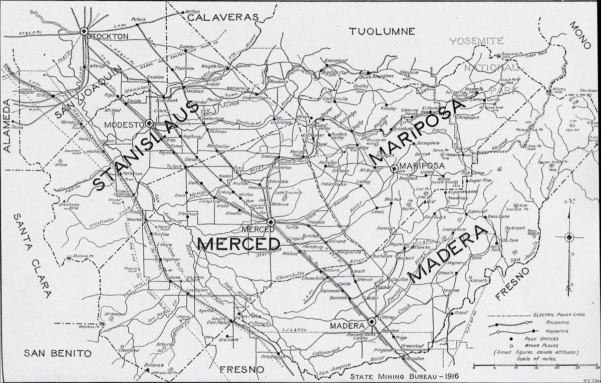
Tombstone rock appears commonly between Planada and Merced Falls, and scattered through out the mapped area. CLICK map to expand and enlarge
This area of distinctive rock was discovered early in the twentieth century.
Excerpt from Slate in the United States, Bulletin 586, by T. Nelson Dale and Others, United States Geological Survey, Washington: Government Printing Office, 1914, pp. 70.)
“A slate deposit was discovered in 1912 about 11 miles east of Planada, probably the Mariposa slate and of Jurassic age.* It is reported as 1,500 feet in width at the surface, 3 miles in length, and 300 feet in vertical thickness.
Morning Light
On a trip north of Mariposa in early morning light, tombstone slate shows off its myriad of colors and we stop on the roadside to photograph the glowing formations scattered in a farmer’s field.

Rock Creek Rd near Copperopolis, CA

Tombstone rocks on Rock Creek Rd, near Copperopolis, CA, opposite the Madame Josephine Felix marker

Jurassic park- tombstone rock along Rock Creek Rd, Copperopolis, CA

Like lichen? A close view of crustose lichens growing on tombstone slate
For geekier “Geo” geeks:
From Geotripper blog: “the old metamorphic rock of the Foothills Terrane start peeking through the soil cover. These so-called “tombstone rocks” are slate and phyllite that originated as mud and silt on the ocean floor which were accreted to the western edge of the North American continent in Mesozoic time…. These rocks are far more resistant to erosion, and form long high north-trending ridges in the western Mother Lode.”
From: Mother Lode Geology: An ocean trench by Buzz Eggleston
“If you drive the full length of Highway 49 you are traveling almost all the way on top of the Melones Fault Zone. This particular zone is notable for two things. One is the gold-bearing quartz it exposes on and near the surface. The other is that long before it was a fault zone it marked the location of a deep ocean trench that stretched northwest to southeast and far to the west. Called by some the Sierran trench, it was a submerged canyon that first formed in an ancient sea more than 200 million years ago.
Mariposa slate, which began as an ocean sediment, is found throughout the foothills of the Mother Lode, sometimes thousands of feet thick. It forms the walls of many road cuts, including a prime example on Highway 49 just north of the Archie Stevenot Bridge that connects Tuolumne and Calaveras counties. It also is exhibited as the tombstone formation rocks that poke up like grave markers, vertically, from hills and pastures in the region.”